

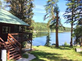
Seeley Lake, Montana
Swan Valley
With the Mission and Swan mountain ranges flanking the Seeley-Swan valley, Seeley Lake is located on Highway 83, just 51 miles northeast of Missoula and 80 miles south of Kalispell. This picturesque town is found on the 91-mile stretch of road commonly known as the ‘Seeley Swan Highway’ or the ‘Chain of Lakes.'
A full service town. It is home to a locally-owned grocery store, pharmacy, hardware store and sporting goods stores, auto repair shops with gas and recreation/sport rentals. Highlighting the community’s welcoming spirit, it is host to a variety of seasonal recreational events. The Memorial Day weekend Loon and Fish Festival, an annual celebration of area wildlife and the 4th of July events are true celebrations of the character of Seeley Lake. During the warmer seasons, folks enjoy birding, wildlife viewing, fishing, camping, boating, hiking, backpacking, horseback riding and golfing and trap shooting. Mountain biking, along hundreds of miles of trails and roads and canoeing the Clearwater River Canoe Trail are quite popular, too.
Area
“Winterfest”, held during the last
“Winterfest”, held during the last two weekends in January, is Montana's premier winter recreation event. The Seeley-Monture 100 sled dog race starts and finishes in downtown Seeley Lake and in February, the 350-mile Race to the Sky sled dog race has a checkpoint in Seeley Lake, making them both spectator friendly events. Seeley Lake is in the heart of a vast network of trails, winding in and around the local mountain ranges, and a world-class Nordic ski trail system. Enjoying the serenity and beauty of the winter wonderland on a horse-drawn sleigh ride or on a guided sled dog ride are experiences the traveler to Seeley Lake will never forget.
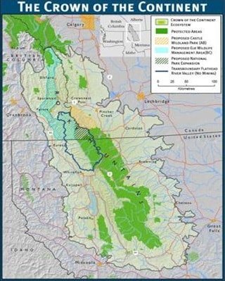
Crown of the Continent
At the narrow waist of the Rocky Mountains, where Alberta, British Columbia, and Montana meet, sprawls one of the wildest, most diverse and intact ecosystems in the temperate zones of the world. In the early 1890s, conservationist and Glacier Park advocate George Bird Grinnell dubbed this trans boundary region the "Crown of the Continent," highlighting the region's geographical importance as the headwaters of the continent, spilling cold, clean waters to the Pacific Ocean, Gulf of Mexico, and Hudson Bay.
The Crown region embraces Waterton-Glacier International Peace Park and the surrounding region of unbroken prairie, deep forest, plunging valleys, and jagged peaks. The Crown is defined largely by the habitat needs of wide-ranging wildlife that thrive here, such as the grizzly bear, wolverine, wolf, and bull trout. Thriving, changing gateway communities also reside here. Native people continue to occupy territory that has been their home for thousands of years, clinging to their ancestral languages and cultural traditions.
The region is bound by the Rocky Mountain Trench on the west and the prairie foothills to the east of the mountains. The southern extent includes the Blackfoot Valley where the forests, waters, and wildlife of the Bob Marshall Wilderness slide into open grasslands. To the north of the region are the Canadian Rocky Mountain Parks of Banff and Kootenay.
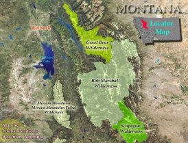
Bob Marshall Wilderness
Located in Northwestern Montana on both sides of the Continental Divide, this large complex includes three Wilderness areas: the Great Bear, the Scapegoat, and the Bob Marshall Wilderness. Together the Bob Marshall Wilderness Complex makes up an area of more than 1.5 million acres, the third largest in the lower 48 states. Grizzly bear, lynx, wolverine, deer, elk, gray wolf, moose, black bear, mountain lion, mountain goat, and mountain sheep roam about these rugged ridge tops, gently sloping alpine meadows, thickly forested river bottoms and open grass parks. Across this continuous landscape over 1700 miles of trail provide challenges and experiences to satisfy visitors with a wide range of skills.

The Continental Divide separates
The Continental Divide separates the Flathead and Sun River drainages with elevations ranging from 4,000 feet to more than 9,000 feet. A huge escarpment called the Chinese Wall, a part of the Divide, highlights the Bob's vast untrammeled beauty, with an average height of more than 1,000 feet and a length of 22 miles. The Chinese Wall extends into the Scapegoat Wilderness, which lies to the south, while the Great Bear Wilderness shares the border to the north.
The United States Congress designated the Bob Marshall Wilderness in 1964 and it now has a total of 1,009,356 acres. All of this wilderness is located in Montana and is managed by the Forest Service. The Bob Marshall Wilderness is bordered by the Great Bear Wilderness to the north and theScapegoat Wilderness to the south.